Search

GEOGRAPHY EDUCATION

Supporting geography educators everywhere with current digital resources.

Military Mobilizations: Ukraine and Russia

See on Scoop.itGeography Education

An important look at the military reality of the crisis.

Seth Dixon‘s insight:

We have known that pro-Russian forces have taken control of government buildings in part of Ukraine, and that forces on both sides have been mobilizing along the border.  It is hard to make sense of all the news reports but this map helps to bring the reality on the ground into sharp focus.  

See on www.washingtonpost.com

Retronyms: Linguistic Shifts

See on Scoop.itGeography Education

A ‘retronym’ is a term specifying the original meaning of word after a newer meaning has overtaken it.

Seth Dixon‘s insight:

Technological change demands linguistic change.  The technological world in which our societies are immersed changes our lived experiences and aspects of culture such as language. For example, vinyl disks were simply called records until compact discs, audio tapes and digital files flooded the music market.  An artist may still cut a record today, but the record probably won’t be available in vinyl.   Vinyl, then, is a ‘retronym’ to now describe what was once called a record, which now has other meanings and connotations. This list has 14 other examples of retronyms, which exemplifies the cultural patterns and processes that create pop culture.  


Tags: language, culture, popular culture, technology.

See on mentalfloss.com

Block-Long Sinkhole Swallows Cars in Baltimore

See on Scoop.itGeography Education

“A block-long sinkhole opened up in a residential neighborhood in rain-soaked Baltimore on Wednesday, devouring cars and forcing the evacuation of several houses.”

Seth Dixon‘s insight:

We like to think that the Earth beneath our feet is solid and that the configuration of the landforms in our neighborhood will be unchanging.  This a dramatic reminder that Earth’s physical processes don’t ever stop–even if we’ve built a city in that spot.

Tags: physical, geomorphology, erosion, landformsweather and climateurban ecology.

See on www.nbcnews.com

Where the extremely poor live

See on Scoop.itGeography Education

Seth Dixon‘s insight:

The World Bank has produced a report entitled “Prosperity for All.”  In this the extremely poor are defined as making less than $1.25 a day.  Two thirds of the extremely poor live in just 5 countries (India, China, Nigeria, Bangladesh and DR Congo). 

Tags: poverty, development, economic, globalization, labor, NGOs.

Defining ‘the South’

See on Scoop.itGeography Education

“The Southerners were considerably more certain of which states are their own. While the top few Midwest states barely pulled 80 percent of the vote, nearly 90 percent of respondents identified Georgia and Alabama as Southern, and more than 80 percent placed Mississippi and Louisiana in the South. South Carolina, Tennessee, Florida and North Carolina all garnered above 60 percent.”

Seth Dixon‘s insight:

I enjoy activities that challenge students to map out vernacular regions since it forces them to establish some criteria and consider the attributes of particular places.  So what does your ‘South’ look like? 

Tags: mapping, the South, regions.

See on fivethirtyeight.com

Tunisia’s street artist

Following the uprising that toppled the government in 2011, he has become a well known graffiti artist hoping to revive and modernise the ancient art of Arabic calligraphy in Tunisia. He calls his style “calligraffiti”.

Seth Dixon‘s insight:

This short BBC video demonstrated how cultures are dynamic and are built on past traditions to confront modern circumstances.  Cultures are performed both as resistance to and wider social influences and as a mechanism to adapt to those forces.  The street art of Karim Jabbari is an excellent example of the cultural patterns and processes by blending ancient North African calligraphy with modern Western street art to create an entirely new form of cultural expression.  This cultural production is still deeply rooted in place, but in not locked away in the past.  After the Arab Spring, Tunisians were searching for new political identities and the street festivals sponsored in part by this artist are forging new political, cultural and urban expressions that honor the past while forging a new future.  Watch the video below to see him in action, shaping a cultural landscape and strengthening a community.    

Tags: Tunisia, globalization, popular culture, unit 3 culture.


Picture1 Picture4Picture3Picture2

China Has Accomplished Something In Global Trade Not Seen Since Colonial Britain

See on Scoop.itGeography Education

China is a true mega-trader — a position last held by colonial Britain, with trade significant not only as a share of world trade (11.5%) but also of its own GDP (47%).  The U.S. is China’s top export destination. China’s trade with Latin America has risen more than 200 times since 1990 and is the fastest-growing corridor. China’s trade is beginning to slow, however. Exports accounted for about 25% of GDP in 2012, down from 35% in 2007.” 

Seth Dixon‘s insight:

This article is highlights what we already know; China is a dominant force in global trade (although the map should be centered on the Pacific to show China’s real shipping lanes and interregional connections).  Containers are symbols of global commerce that enable economies of scale to be profitable and the outsourcing of so many manufacturing jobs to developing countries (almost 90% of everything we buy arrives via ship).  The invention of these containers have changed the geography of global shipping and the vast majority of the world’s largest ports are now in East Asia. 


Tags: transportation, globalization, diffusion, industry, economic.

See on www.businessinsider.com

For the Muslims of CAR, it’s ‘leave or die’

Thousands of Muslims in the Central African Republic have fled as UN chief warns of ‘ethno-religious cleansing’.


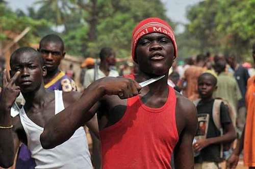
Leave or die.  It’s come down to this for the Muslims of Bangui, the capital of the Central African Republic.  Muslims here once lived freely among the Christian majority, running businesses and praying in mosques. Now, many of the city’s Muslims have fled, and on Sunday about 1,300 Muslims from Bangui’s PK12 neighbourhood were evacuated to safety by peacekeeping forces.

Already one of the world’s poorest countries, CAR has seen a wave of upheaval and violence in the past 15 months. The 10-month reign of the Muslim-dominated Seleka rebel group inflamed intercommunal tensions in the country, and spurred the rise of Christian militias called the anti-Balaka.  Once the Seleka was forced out of power in January, the anti-Balaka rampaged, targeting Muslims across the country for their perceived support of the Seleka and its bloody excesses.

See on www.aljazeera.com

Google Maps Displays Crimean Border Differently In Russia, U.S.

See on Scoop.itGeography Education

“America and its allies have refused to accept the region’s separatist move to join Russia.  A look at the maps available on two Google Maps Web addresses — one ending in .com and another in .ru — shows the disparity. In Russia, Web visitors see a solid line dividing Crimea from neighboring Ukraine. In the U.S., a dotted line separates the two, implying a disputed status within the country.”

Seth Dixon‘s insight:

This isn’t the only international border dispute that is displayed differently in Google Maps.  Google uses over 30 distinct versions of international borders.  This brings up more questions than it answers–How is the Kashmir displayed in India?  Pakistan?  The West Bank in Israel or Egypt?  If you haven’t explored Google Maps in other languages, consider this your invitation to read maps as you would a text and to think about the political implications of making a map.   

Tags: google, mapping, borders, political.

See on www.wbur.org

Create a free website or blog at WordPress.com.

Up ↑