Search

GEOGRAPHY EDUCATION

Supporting geography educators everywhere with current digital resources.

Clinton would have won if the United States looked like the top map

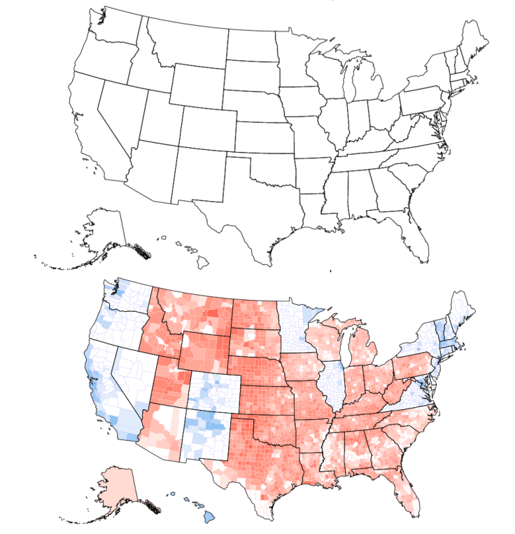
Can you tell what’s wrong with this map of the United States? I’ll give you a hint: Look near the Great Lakes and the Gulf of Mexico. Spot the problem yet? A further hint: Look at the border of Wisconsin and Illinois as well as the Florida Panhandle. See it now? The Wisconsin-Illinois border is slightly more southern and the Florida Panhandle is slightly shorter.

Source: medium.com

This mapping application is my favorite discovery after the 2016 U.S. Presidential Election.  The election was obviously very contentious and incredibly close, both in regard to the popular vote as well as the Electoral College.  Using this mapping application, you can re-divide the states of the union by shifting the counties around.  Using the voting patterns based on the county-level data, you can see how your proposed divisions would have impacted the 2016 presidential election. 

There have been many plans on how to divide the 50 states into various regional configurations (50 states of equal population, regions of economic interactions, cultural regions, and the Nine Nations of America), and this is another iteration of that age-old theme. While this isn’t an activity in gerrymandering in the strictest sense (this is not reapportioning within the state based on population change but between states), it shows just how gerrymandering works.  It takes 270 electoral votes to win the presidency, but you could make it a landslide (in either direction) if you manipulate the current state borders.  The highest electoral vote I could engineer for Donald Trump was 407, and the highest electoral total I could manufacture for Hillary Clinton was 402.  The point of this is to show that the balance within and among states can be far more delicate than we might presume.  Just a line here or a line there can dramatically alter the balance of power.        

Activity #1: Try to make this a landslide victory for the Republican Party.  How many electoral votes could you garner for the Republicans? Add a screenshot.

Activity #2: Try to make this a landslide victory for the Democratic Party.  How many electoral votes could you garner for the Democrats? Add a screenshot.

Activity #3: Try to tip the election to the Democrats with the most subtle, minor changes that might go under the radar. Explain your changes to the state map.  Add a screenshot.   


Tags: gerrymandering, political, mapping, census, unit 4 political, regionsNorth America.

11 Facts About Food Deserts

“Food insecurity has a high correlation with increased diabetes rates. In Chicago, the death rate from diabetes in a food desert is twice that of areas with access to grocery stores.”

Source: www.dosomething.org

Food deserts are places where residents have limited access to healthy food.  Here is a great map from the U.S. Dept. of Agriculture that shows low-income census tract that are more than one mile from supermarkets and rural areas that are more than 10 miles from the nearest supermarket.  Esri has also produced a food desert map that shows where unserved people (farther than 1 mile in urban/10 miles in rural) live in poverty.  For a household with a private automobile, distance to a supermarket isn’t that crucial an issue, but without an automobile, this lack of healthy food available becomes a significant challenge for residents that live in this neighborhood.  


Tags: food, urban, povertyplace, socioeconomic, food desert.

Bamenda protests: Mass arrests in Cameroon

Some 100 people are arrested after protests against using French in Cameroon’s English-speaking region.


Areas controlled by Britain and France joined to form Cameroon after the colonial powers withdrew in the 1960s. The country has 10 semi-autonomous administrative regions – eight are Francophone and use the French civil law. English-speakers have long complained that they face discrimination. They often complain that they are excluded from top civil service jobs and that government documents are often only published in French, even though English is also an official language. Bamenda is the founding place of Cameroon’s largest opposition political party, the Social Democratic Front.


Tags: language, colonialism, CameroonAfrica, culturepolitical, devolution.

Source: www.bbc.com

Judges Find Wisconsin Redistricting Unfairly Favored Republicans

A federal panel called the 2011 redrawing of Wisconsin Assembly districts an unconstitutional gerrymander, ruling in a case that could go to the Supreme Court.

Source: www.nytimes.com

The redistricting process is far from neutral; to be fair we should remember that gerrymandering has happened on all ends of the political spectrum, depending on who is charge during the redistricting process (after the decennial census).  Which map to you think is the best way to divide these districts?  What is the fairest way to divide them?

Tags: gerrymandering, political, mapping, census, unit 4 political.

After a Tornado, Greensburg, Kansas, Rebuilt Green. Was It Worth It?

A decade ago, a tornado wiped out the small town of Greensburg, Kansas. But the town decided to rebuild—as a totally green community. Ten years out, has the green rebuilding program been successful, and is this a model that might be used by other towns? Or is going green harder than it seems?

Source: www.slate.com

If you haven’t discovered the podcast “Placemakers” you are missing out.  The entire series centers around the challenges that confront different types of communities and the opportunities to improve the way things work. They present “stories about the spaces we inhabit and the people who shape them. Join us as we crisscross the country, introducing you to real people in real communities—people who make a difference in how we travel, work, and live. You’ll never look at your community the same way again.”  And yes, that sounds like a whole lot of applied geography to me.   


Tagsplace, tornado, weather and climate, planning, podcast.

Thanksgiving Resources

Supporting geography educators everywhere with current digital resources.

Source: www.scoop.it

Looking for some Thanksgiving resources?  Here you go. 


Tags: Thanksgiving, food, seasonal.

The Spice Trade’s Legacy

“In its day, the spice trade was the world’s biggest industry. It established and destroyed empires and helped the Europeans (who were looking for alternate routes to the east) map the globe through their discovery of new continents. What was once tightly controlled by the Arabs for centuries was now available throughout Europe with the establishment of the Ocean Spice Trade route connecting Europe directly to South Asia (India) and South East Asia.”

Source: cleanfooddirtygirl.com

The spice trade changed how we eat forever but it did so much more.  The fall of Constantinople to the Ottoman Empire cut off Europe from the vital trade routes to the east and access to the most prized commodities of the day.  What drove European exploration to get around Africa and to cross the Atlantic?  It was to reshape their situation location relative to the economic networks that shaped the emerging global economy.  In essence, the spice trade reshaped the fortunes and trajectories of several major world regions.   


Tags: Southeast Asia, food productiondiffusionglobalization, agriculture, economicindustry, economic, historical, regions.

American football has taken root in Mexico at all levels

“Why is the NFL in Mexico? A visitor to the capital city can sense right away why the league is so bullish on the country’s potential.”


The last time the NFL ventured into Mexico was in 2005, when the Arizona Cardinals beat the San Francisco 49ers in Estadio Azteca. Top-level American football is returning to the same venue in Mexico City on Monday night, when the Houston Texans and Oakland Raiders will face off in a contest that has been sold out since July.

Just don’t assume the 11-year gap is related to a lack of interest. In reality, Mexico is the top international hotbed for American football, with the largest NFL fan base of any country outside the United States. There are more fans of the league in Mexico City than in most actual NFL markets.

But the sport’s popularity in Mexico goes well beyond NFL fandom. From youth leagues that are overtaking soccer in popularity in some parts of the country to a new pro league, American football is a major player south of the border. With that in mind, here’s a closer look at where the sport stands on every level in Mexico and how fans there consume the game.


Tagssport, popular culturediffusion, culture, Mexico, Middle America.

Source: www.espn.com

New Zealand quake lifted seabed by 2m

The 7.8 magnitude earthquake that hit New Zealand’s South Island lifted up the seabed by two metres, pushing it above the ocean’s surface.

Source: www.9news.com.au

Plates on the Earth’s crust typically move forward at very slowly (about the same speed as the fingernail growth).  While that is the usual, plates snag along the edges and pressure can build over the years, only to lead to explosive, quick changes like happened recently in New Zealand.  This complex series of tremors has people disconnected as much of the physical infrastructure has be damaged


Tags: New Zealandphysical, tectonicstransportation, geology, geomorphology.

Blog at WordPress.com.

Up ↑