Search

GEOGRAPHY EDUCATION

Supporting geography educators everywhere with current digital resources.

Author

sethdixon

I am a geography professor at Rhode Island College.

Geospatial mapping enhances Arlington National Cemetery management

Via Scoop.itGeography Education

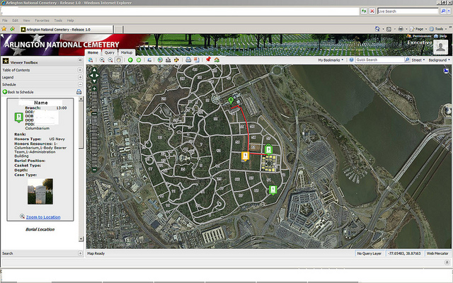
Officials at Arlington National Cemetery will use an Army-designed geospatial mapping system to manage cemetery operations, the executive director of the Army National Cemeteries Program said March 8, 2012.  

This is another fantastic example of how GIS, GPS and online mapping can be used within many diverse projects.  Mapping cemeteries can be an excellent service learning project for a GIS class and the exploring local cemeteries is a very hands on method for exploring local history in a way that makes place matter. Geographic skills and spatial analysis is increasingly critical in the 21st century as we’ve seen an explosion of online applications for geospatial technologies.
Via www.army.mil

The Islamic World’s Quiet Revolution

Via Scoop.itGeography Education
“Forget politics. Muslim countries are poised to experience a new wave of change — but this time it’s all about demographics.”   

For generations the talk about demographics has been that Muslim-majority societies have cultural factors that keep fertility rates high despite the global trend that indicates that fertility rates will drop as societies become more wealthy and developed.  This ‘cultural immunity’ is not as impermeable as was once thought and we are now seeing falling birth rates and fertility rates throughout the Muslim World.  This article is heavy on statistics and charts, which would be a benefit to student as a potential Free Response Question.
Via www.foreignpolicy.com

Following ‘Geography Education’

Via Scoop.itGeography Education

I’m incredibly excited about all the support I’ve received from my readers. Currently we are averaging approximately 10,000 page views a month and I’ve been looking for new ways to keep my readers current with posted materials. I’ve recently created a Facebook page, which can act as a way to receive notices, discuss posts and how to use them and to make suggestions for future posts. Feel free to connect with in any way that fits with your social media networks. Also, this WordPress site (since I can control the layout more) will be that long-term site that hosts all the others.  The content will be on wordpress, Tumblr and Scoop.it.   Facebook, G+, Twitter and Pinterest will alert you when there is updated content.  Thank you for following!

Facebook Page, Google+, Pinterest, Twitter, Tumblr, WordPress and Scoop.it!

What March Madness Can Teach Us About the Economic Geography of Sports

Via Scoop.itGeography Education

The Atlantic Cities:  What exactly can account for the dominance of small and medium sized metros generally and college towns in particular in the economic…

While it is clear that superstar athletes in the professional ranks are concentrated in the largest cities, college athletics still let’s the ‘Davids’ compete with the ‘Goliaths.’  Interestingly, the largest cities don’t have the highest per capita concentration of athletes but many small college towns do.  Among the Top 25 cities with the highest concentration of athletes in the workforce (include scholarship athletes) we find South Bend, Indiana, home to Notre Dame; Auburn, Alabama, home to the university that bears its name; Ames, Iowa, home of Iowa State; Blacksburg, Virginia (Virginia Tech); Burlington, Vermont (University of Vermont); and Boulder, Colorado (University of Colorado).
Via www.theatlanticcities.com

Google Earth in China

Via Scoop.itGeography Education

This gallery of Google Earth Screen shots primarily from Yunnan Province in Southern China (bordering Vietnam and Burma) brings some keen spatial analysis to those unfamiliar with the region.  This is also a great example of using geospatial technologies to interpret the cultural landscape–the merger of ‘people and pixels’ as the textbook of the same name encourages with classrooms.  While the quality of this work is above what would be expected of students, a Google Earth project designed to get students to reassess the spatial dynamics within their neighborhood or home state could lead some fantastic projects.
Via www.facebook.com

America Is Stealing the World’s Doctors

Via Scoop.itGeography Education
Who wants to practice medicine in a country where they use power tools in surgery? The dilemma of doctors in the developing world.  

This article’s title is inflammatory, but it touches on some very real interconnected geographic issues.  Economic development in the many parts of the world is complicated by the migration issue of ‘brain drain.’  The individual choices that doctors from the less developed world face often lead the best and brightest workers to leave their home country.  If you could make a very good living as in the United States(the median salary of a surgeon in New Jersey is $216,000) or go back to your home country where your skills are more desperately needed (in Lusaka, Zambia a surgeon makes about $24,000 a year), which would you choose?  This is not a hypothetical example (nor one with only one right answer) but one rooted in a globalized economy, where the places that offer the greatest opportunities for individual advancement get the top talent–excellent for the individual and family economies but problematic at the national scale.
Via www.nytimes.com

Pass the Books. Hold the Oil.

Via Scoop.itGeography Education
Education is a better economic driver than a country’s natural resources.

This New York Times article is compelling fodder for a discussion on economic development.  While having natural resources on the surface sounds like the best valuable asset for a nation economy, why does Friedman argue that an abundance of natural resource can hurt the national economy?  While an educated workforce is obviously an asset, just how important is it compared to other factors?
Via www.nytimes.com

Kiribati and Climate Change

Via Scoop.itGeography Education
Fearing that climate change could wipe out their Pacific archipelago, the leaders of Kiribati are considering an unusual backup plan: moving the population to Fiji.  

How urgent is the issue of climate change?  That question is not only geographic in content, but the response might also be somewhat contingent on geography as well.  If your country literally has no higher ground to retreat to, the thought of even minimal sea level change would be totally devastating.
Via www.mercurynews.com

What Geography Can Teach Us About Basketball

Via Scoop.itGeography Education

Maps That Show NBA Players Where to Shoot…   What is considered a good play or a bad play in most sports is situational and depends on context.  One of the many contexts in basketball that determines that constitutes ‘a good shoot’ is where you are on the court in relation to the hoop.  In essence, this is a spatial factor, and spatial analysis is critical to informing sports strategy and a geography professor did just that in this study.  In this month of March, mentioning sports in a geographic context might help students see how spatial analysis matters is a wide range of subjects.
Via www.slate.com

Create a free website or blog at WordPress.com.

Up ↑