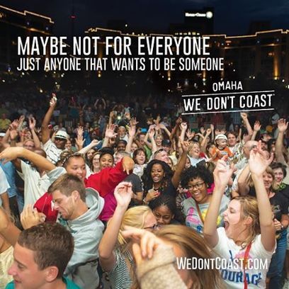
Search

GEOGRAPHY EDUCATION

Supporting geography educators everywhere with current digital resources.

Category

Uncategorized

Visualizing the Global Economy

The graphic above (Voronoi diagram) represents the relative size of each country’s economy in terms of nominal GDP: the larger the area, the larger the size of the economy. The areas are further divided into three sectors: services, industrial, and agricultural. The US economy is mostly composed of companies engaged in providing services (79.7% compared to the global average of 63.6%), while agriculture and industry make up smaller-than-average of portions of the economy (1.12% and 19.1% compared to averages of 5.9% and 30.5%).


Tags: globalization, industry, economic, visualization.

Source: howmuch.net

It’s official: a global mass extinction is under way

“New research confirms that the next mass extinction is in progress, and we’re the cause. There’s been little doubt that humans have been severely altering the planet and reducing biodiversity, but it has been unclear how many species go extinct under normal circumstances, without human influence.

This new research clarifies the rate of ‘background extinction’ (the rate of extinction during the point before humans became a primary contributor to extinction). The research confirms that human activity is driving species extinct at a rate far higher than the background rate. A look at previous events suggests cause for concern. Geologists recognize five previous mass extinction events— the end of the Ordovician, Devonian, Permian, Triassic, and Cretaceous periods, meaning that we’re now in the 6th.”


Tagsphysical, biogeography, environment, ecology, environment modify, sustainability, geology.

Source: daily.jstor.org

Why Children Still Need to Read (and Draw) Maps

While many skills have become obsolete in the digital age, map reading remains an important tool for building children’s spatial reasoning skills and helping them make sense of our world.

Source: www.pbs.org

Young people need to develop a mental map of their environs and an over-reliance on GPS/mapping apps are no substitute.  When these youth become drivers, they are unprepared to make spatially/navigational decisions because they lack map reading skills.  They might think that their apps can do all the work and that an old fashioned paper map is outdated technology, but their spatial thinking skills become atrophied. Spatial skills are crucial for understanding the world as a global citizen, to understand your local environs and for making scientific discoveries.  So teach a kid how to read a map…the sooner the better. 


Why should we teach geography?

“One reason why geography has languished in the curricula of many American schools is that so few people understand the nature of the discipline or its relevance to our everyday lives. What is geography? What is its unique perspective? What do geographers do? Why is geography important? Why should we teach (and learn) geography in the schools? These are questions that have gone largely unanswered in American education. This brief essay presents an easily taught, understood, and remembered definition of geography.”

Source: www.instagram.com

Why does geography education matter? This poster nicely summarizes the classic essay on what geography is and what geographers do…it’s a perfect article for high school and college student to read since it is very accessible.

How ‘Ugly’ Fruits and Vegetables Can Help Solve World Hunger

About a third of the planet’s food goes to waste, often because of its looks. That’s enough to feed two billion people.

Source: www.nationalgeographic.com

No one should be surprised that more developed societies are more wasteful societies.  It is not just personal wasting of food at the house and restaurants that are the problem.  Perfectly edible food is thrown out due to size (smaller than standards but perfectly normal), cosmetics (Bananas that are shaped ‘funny’) and costumer preference (discarded bread crust).  This is an intriguing perceptive on our consumptive culture, but it also is helpful in framing issues such as sustainability and human and environmental interactions.  In a technologically advanced societies that are often removed form the land where the food they eat originates, food waste needs to made more explicit. 

Tags: food, agriculture, consumption, sustainability, unit 5 agriculture.

26 Things You Might Not Know Were Named After Places

From cheddar cheese to the tuxedo.

Source: mentalfloss.com

Many ordinary objects are named for places where they were discovered, invented, or widely used. If you smell a dab of cologne on the man eating a Danish in the bungalow, the way you speak about that incident has a linguistic debt to a town in Germany, and the countries of Denmark and Bangladesh.  Many foods (especially wine and cheese) are named after places and 26 are highlighted in this article and here is a (semi-) exhaustive list of words derived from toponyms


Tags: food, language, toponyms.

AAG’s Interactive Modules

“Each module consists of a conceptual framework and case studies. The conceptual framework introduces students to some of the key concepts, theories, and analytical approaches in geography. The conceptual framework provides students with the background they need to think geographically about global issues. The case studies illustrate how geographic concepts, methods, and technologies can be used to investigate and solve problems in different places and countries.”

Source: www.aag.org

These 6 interactive modules from the AAG are an untapped treasure trove of resources; they make geographic methods/content relevant using a wide range of global case studies.  Each of these modules has been aligned with the APHG curriculum and can be adapted to a wide range of applications.  This is definitely on the shortlist of the best resources that I’ve shared over the years.  


TagsAAG, APHG, edtech.


Interactives about Syrian Refugee Crisis

War, sectarian violence, and famine have forced more than 50 million people from their homes—the largest number of displaced people since World War II.

Source: storymaps.esri.com

Here are two excellent ESRI StoryMaps about the Syrian refugee crisis; these are two very good examples of a great web maps. 


Tags: GIS, ESRI, mapping, cartography, geospatial, edtech, Syria, political, refugees.

Opinion: Sadly, Malthus was right. Now what?

We seem bound to learn the hard way that there really is a limit to how many people the Earth can support.

Source: montrealgazette.com

The ideas of Thomas Malthus have always loomed large; the scope includes some of the biggest issues facing humanity’s continued existence on this planet.  His controversial ideas have been debated for centuries and the way we frame the debate is oftentimes in terms that are derived from Malthusian ideas (for example the terms overpopulation, carrying capacity, and sustainability).  This op-ed written by the President of the Canada’s Population institute provides a way to get student to assess the strengths of an argument and to identify the bias/perspective of the author.  

Questions to Ponder: What did Malthus get right?  What did he get wrong? 

Tags: Demographics, population, APHG, unit 2 population

Blog at WordPress.com.

Up ↑